
From Space to Plate: How Earth Observation Can Improve Food LCAs

Why measuring food emissions matters
Food systems account for roughly 30% of global greenhouse gas emissions. Reducing these emissions requires first measuring them in a reliable and consistent way.
Life Cycle Assessment (LCA) is the standard method used to quantify the environmental footprint of food products across the entire value chain, from agricultural inputs and on-farm production to processing, transport, and packaging. Today, LCAs play a central role in sustainability reporting, product comparisons, and climate strategies across the food industry.
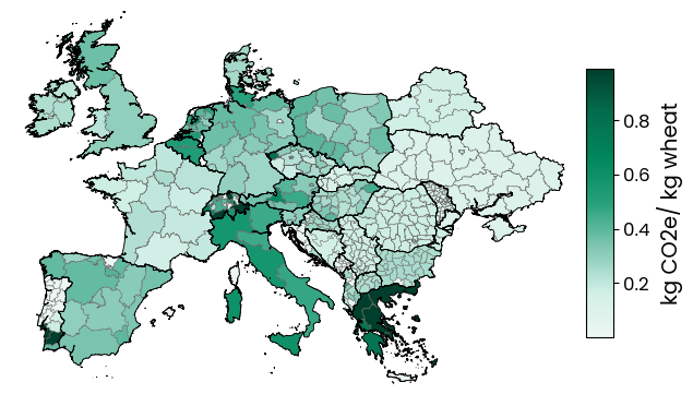
In practice, however, many food LCAs still rely on sparse and largely static datasets. These models struggle to reflect how environmental impacts vary across regions and over time, even though food systems themselves are anything but static. Two packs of flour can have very different footprints, depending on how and where the wheat was grown. Differences in yield, soil characteristics, climate conditions, or water availability can all lead to substantially different environmental outcomes, even when the final product looks identical on the shelf.
A common response is the use of primary data, such as farm surveys or on site measurements, to better reflect real world practices. While this approach can improve accuracy at the individual site level, it quickly becomes impractical when sourcing spans hundreds or thousands of producers across multiple regions. As of today, there is still no broadly standardized approach for collecting and integrating such data at scale, and assessments often rely on government level averages or highly aggregated inventories, which limits spatial resolution.
Bringing space and time into LCA with Earth Observation
This is where Earth Observation comes into play. Earth Observation (EO) refers to the use of satellite data to monitor conditions on the Earth’s surface over time. In agriculture, this includes insights into crop growth, irrigation patterns, weather dynamics, and land use change.
Over the past decade, several satellite missions dedicated to monitoring land and agricultural systems have been launched, expanding the availability and resolution of data relevant for food production. As a result, satellites now provide consistent, large scale observations that make it possible to track how agricultural systems behave across regions and seasons, without relying on extensive on the ground data collection.
At Niatsu, we use this information to build agricultural life cycle inventories from scratch by bringing together all inputs needed to produce a kilogram of crop and enriching them with EO data where it makes sense. This allows LCAs to move beyond static averages and better reflect real world production conditions. By accounting for factors such as yield, irrigation, water stress, and land use change at a regional level and over time, environmental footprints become more realistic, easier to compare, and more spatially detailed.
From rough estimates to actionable insights
In a food system where production conditions can change from one region or season to the next, adding this spatial and temporal context helps move from rough estimates toward insights that better reflect reality and are ultimately more useful for decision making along complex food supply chains.